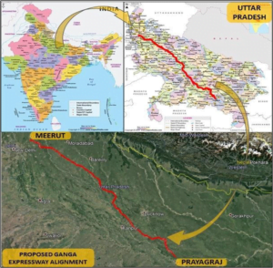
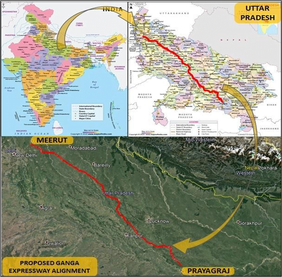
Ganga Expressway: PROJECT ALIGNMENT DESCRIPTION
The proposed Ganga Expressway starts from km 16+000 of Meerut–Bulandshahar (NH-334) near village Bijoli (Dist. Meerut) (CH 7+900) & terminates at Prayagraj Bypass on NH-19 near village Judapur Dando (Dist. Prayagraj) (CH 601+847).
The length of the proposed expressway alignment is 593.947 km.

The proposed expressway has been divided into 12 packages. The chainage wise detail of the packages has been given below:
| Package No. | Section Details | Chainage (km) | Length | |
| From | To | |||
| I | From Village Bijoli (Dist. Meerut) to Village- Chandner (Dist. Hapur) | 7.900 | 56.900 | 49.000 |
| II | From Village-Chandner (Dist. Hapur) to Village- Mirzapur Dugar (Dist. Amroha) | 56.900 | 86.900 | 30.000 |
| III | From Mirzapur Dugar (Dist. Amroha) to Village- Nagla Barah (Dist. Budaun) | 86.900 | 137.600 | 50.700 |
| IV | From Village-Nagla Barah (Dist. Budaun) to Village-Binawar (Dist. Budaun) | 137.600 | 189.700 | 52.100 |
| V | From Binawar (Dist.Budaun) to Girdharpur (Dist. Shahjahanpur) | 189.700 | 236.400 | 46.700 |
| VI | From Village- Girdharpur (Dist. Shahjahanpur) to Village-Ubariya Khurd (Dist. Hardoi) | 236.400 | 289.300 | 52.900 |
| VII | From Village-Ubariya Khurd (Dist. Hardoi) to Village- Pandra Lakhanpur (Dist. Hardoi) | 289.300 | 341.700 | 52.400 |
| VIII | From Village- Pandra Lakhanpur (Dist. Hardoi) to Village-Raiyamau(Dist. Unnao) | 341.700 | 391.900 | 50.200 |
| IX | From Village- Raiyamau (Dist. Unnao) to Village-Sarso (Dist. Unnao) | 391.900 | 445.000 | 53.100 |
| X | From Village- Sarso (Dist. Unnao) to Village- Terukha (Dist. Raebareli) | 445.000 | 496.800 | 51.800 |
| XI | From Village-Terukha (Dist. Raebareli) to Village-Arro (Dist. Pratapgarh) | 496.800 | 548.800 | 52.000 |
| XII | From Village- Arro (Dist. Pratapgarh) to Village- Judapur Dando (Dist. Prayagraj) | 548.800 | 601.847 | 53.047 |
| Total | 593.947 |
The Expressway is access controlled with only entry/exit at Nodes (intersecting points of National Highway or State Highways or Major District Roads – crossing with the proposed Expressway Alignment), details of which has been described below.
Alignment & Structures
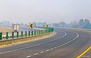
The expressway alignment is having 6 Lanes with Paved Shoulders Configuration with Service Roads, which is further expandable up to 8 Lanes. The alignment has been designed with the design speed of 120 km/h.
Ganga Expressway: Node Development
The Expressway is access controlled with only entry/exit at Nodes (intersecting points of National Highway or State Highways or Major District Roads – crossing with the proposed Expressway Alignment).
| Toll Nodes | Chainage | Details of the Intersecting Roads | Road No. | Type of Interchange |
| A | 0+100 | Delhi – Meerut Expressway | Expressway | Dummy Node |
| B | 8+920 | Meerut – Hapur | NH-334 | Trumpet |
| C | 35+270 | Hapur – Garhmukteshwar | NH-24 | Diamond |
| D | 54+640 | Bulandshahr – Garhmukteshwar | SH-65 | Diamond |
| E | 74+181 | Hasanpur-Anupshahar | MDR-162W | Diamond |
| F | 102+427 | Anupshahr – Moradabad | ODR | Diamond |
| G | 123+288 | Babrala – Chandausi | NH-509 | Double Trumpet |
| H | 173+454 | Chandausi – Budaun | SH-125 | Diamond |
| I | 189+394 | Budaun – Bareilly | SH-33 | Double Trumpet |
| J | 255+167 | Farukkhabad – Shahjahanpur | SH-29 | Double Trumpet |
| K | 282+845 | Farukkhabad – Shahbad | SH-138 | Diamond |
| L | 329+945 | Kannauj– Hardoi | SH-21 | Double Trumpet |
| M | 378+136 | Agra – Lucknow Expressway | Agra Lucknow Exp | Double Trumpet |
| N | 420+932 | Kanpur – Lucknow | NH-27 | Diamond |
| O | 487+285 | Lalganj – Raebareli | NH-31 | Double Trumpet |
| P | 517+708 | Raebareli–Unchahar | NH-30 | Double Trumpet |
| Toll Nodes | Chainage | Details of the Intersecting Roads | Road No. | Type of Interchange |
| Q | 554+951 | Manikpur – Bela Pratapgarh | MDR-102E | Diamond |
| R | 600+457 | Prayagraj Bypass | NH-19 | Trumpet |
Node A is revised and treated as Dummy Node, as the Start Point of the Ganga Expressway has been changed from Node A to Node B due to Engineering Design Constraints, with prior approval of UPEIDA.
GANGA EXPRESSWAY: RIGHT OF WAY
ROW has been taken as total 120 m for the proposed expressway except at Interchange Locations, Toll Plaza locations and at locations for training on the course of nallah/drain, where the ROW varies.
ABUTTING LAND USE PATTERN
The land use pattern on the both sides of the expressway in maximum section is agricultural.
TERRAIN
The terrain of this stretch can be termed as plain and flat throughout.
FOREST
No forest land observed along the road. However, the alignment passes some stretches of Social Forestry.
ARCHEOLOGICAL/ANCIENT STRUCTURE
No such type of structure found along the project corridor.